
 |
LIFETIME of WALKS by DEREK HARWOODDerek Harwood's Walking Records If you have any queries about the pictures or descriptions e-mail me at: derek@harwoodonline.com | ||||
 | |||||
| LICKEY HILLS COUNTRY PARK
Tuesday 17th November 2009 ..............................Walk No. 778 |
 | ||||
Other Walks No 61                                  Total 1261.5 miles


Time Taken:  2.25 hrs     Distance:      Enjoyment:       Weather:      Mild, Windy
 10:37 am - 12:52 pm         4 miles              85%                         Bright Periods

Temp:    Cloud:     Rain:   Visibility:  Ground Conditions:     Wild Life:     Cattle
 13oC        70%       Spots      Good             Muddy                   Autumn Leaves

Total AA:      Total MH:    Total LD:      Total AW:      Other:       Total Distance:
 1043.5 mls    931.5 mls    2198.5 mls      162 mls      1261.5 mls       5597 miles

Companions:   (Derek)  Ken

Points of Interest and LINKS:
Longbridge - Today                   Longbrdige - History               Longbrdige - Recently
Lickey Hills                                   Country Park                      Beacon Hill - Views
Lickey Hills - Pictures              Lickey Hills - History          Lickey Hills - Short Walk


Beacon Hill - 297 metres (975 feet)
Description:
Travelled to Lickey Hills with Ken, by bus to terminus of number 47. Walked along Groveleey Lane (B4096), to bottom of Bilberry Hill, at the Oak Tree Public House roundabout. Continued up Rose Hill (also B4096), to public footpath on left, signed 'Visitors Centre', before hotel on right. Steady ascent up good track to visitors centre and welcome cup of tea. Short time to investigate the information available and decide the best route to the Country Park. Looked for the chosen route from the centre but couldn't find the footpath from the Old Peoples Home. Back tracked to Warren Lane by visitor centre and found a track just past the cottage after the Old Peoples Home. Muddy in the wood to Rose Hill Road, then took signed track by lake towards Beacon Hill. Over bridge at end of lake to ascent alongside a delightful series of small waterfalls and pools. Then into the woods to the top of Beacon Hill and the Toposcope on the summit at 297 metres (975 feet). Just before summit we checked the best route to the top by asking Steve from Rubery, a semi retired Mental Health Nurse, who was jogging by. After a good natter we climbed over the Toposcope and enjoyed the extensive views across Birmingham City. Steve pointed out the old hospital with a green domed roof where he once worked. Must admit when I saw 'Toposcope' on the finger signposts, I wondered what we were heading for, but the mystery was a pleasant surprise. Well done the Cadbury Brothers. Descended from the summit along the edge of the wood, passing a line of benches, all dedicated to lovers of the Lickey Hills. Crossed the golf course with care, between the trees with leaves of different shades of gold. Pity sun wasn't out at this point. Followed footpath sign from golf course into wooded Lickey Hills, but path dwindled to nothing. Eventually found good path leading to Rose Hill Road and a further descent to Oak Tree Public House on roundabout at foot of Bilberry Hill. After an excellent pie and pint we returned along Groveley Lane to bus terminus. Good to get on the hills again.
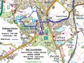
Location: www.streetmap.co.uk, - Start & Finish: from Crofton Hackett 400820/276035, - via: Lickey Hills - Visitor Centre 399797/275357, - via: Beacon Hill 398757/276012 (Click on location and use Zoom and BACK Buttons). Hazards: Always take extra care when crossing golf courses. Most golfers are concentrating on their swing so much, they don't worry about walkers. Click Here to Return to 'Lifetime of Walks' Homepage | |||||
 |
|||||
 |
|||||
 |
|||||
|
|||||
 |
|||||
 |
|||||
 |
|||||
 |
|||||
 |
|||||
 |
|||||
 |
 |
 |
 |
 |
|
| Previous Walk : Next Walk : More Photos : 'Warwickshire Ramble' Photos : 'Lake District' Photos | |||||
| News : Formula 1 : Walking : Table Tennis : Bellringing : My Friends : My Guestbook : CV : Links | |||||
Derek Harwood: Copyright 2009 Devised: November 2009 | |||||